Context
Context
NavigAR is an augmented reality (AR) navigation app designed to simplify wayfinding in complex environments. The project aims to address the challenges faced by individuals in navigating unfamiliar spaces, where traditional maps and directions often fall short. By leveraging AR, the app overlays digital information onto the physical world, guiding users more intuitively. Another key goal is to improve space retention and enhance users' ability to recall routes, making navigation easier and more efficient over time.
NavigAR is an augmented reality (AR) navigation app designed to simplify wayfinding in complex environments. The project aims to address the challenges faced by individuals in navigating unfamiliar spaces, where traditional maps and directions often fall short. By leveraging AR, the app overlays digital information onto the physical world, guiding users more intuitively. Another key goal is to improve space retention and enhance users' ability to recall routes, making navigation easier and more efficient over time.

The image target used to project the AR map.
Background
Background
Navigating unfamiliar environments can be challenging, especially when traditional maps and signs fall short. At IIIT Delhi, visiting students often got lost during college festivals, struggling to find their way around the campus. Even our own freshmen faced difficulties remembering routes and navigating the campus, a problem also shared by autorickshaw drivers unfamiliar with the layout.
These navigation challenges stem from the limitations of current systems, where users often experience information overload, struggling to identify key landmarks or Points of Interest (POIs). Research indicates that such systems do not effectively support spatial learning, leaving users disoriented and frustrated.
To address these issues, our solution leverages Augmented Reality (AR) to project an interactive, digital overlay of the campus. By integrating AR, NavigAR aims to reduce information overload, helping users more easily identify and retain key landmarks. Literature suggests that AR-based solutions, such as Virtual Global Landmarks (VGLs) and improved referents, enhance spatial knowledge and provide a more intuitive navigation experience, making it an ideal approach for our campus navigation challenges.

Methodology and Results
Methodology and Results
The main goal of NavigAR is to make it easier for first-time visitors to navigate a college campus. Using Unity Software, we followed this approach:
Identifying and placing AR markers across pivotal points within the campus.
Developing a robust AR app that efficiently recognises these markers and displays a detailed 3D model of the campus and a marker to pinpoint the user’s current location.
Crafting a user-friendly interface for users to select various locations and view routes to guide them to their destination.
Information Architecture
To avoid an information overload, we first created a rigid Information Architecture to distribute the features and let the user navigate the UI quicker as seen below.
To avoid an information overload, we first created a rigid Information Architecture to distribute the features and let the user navigate the UI quicker as seen below.

3D Development
We created 3D models of the campus from scratch using the design tool Spline. However, according to the free plan, we could only export .gltf files without colour. We then had to convert these .gltf files to .obj format and import them into Blender. We then imported this .obj file to Unity and created the working prototype.
The 3D model enhances user experience and aids in spatial orientation, allowing users to understand where they are scanning from relative to other buildings and landmarks. Once the user scans the model, they are shown a pointer indicating their current position.

The map, as made in spline.
Interactivity and User Interface (UI) Development
The core of our navigation system is driven by C# scripts that handle all the behind-the-scenes functionality of the UI. When a user selects a destination—whether it's a building, medical center, water cooler, or ATM—the appropriate script activates, highlighting a path in a blue-green gradient, echoing our college colors. This ensures users are guided smoothly to their desired location.
To enhance the AR experience, we designed an AR-friendly UI that allows users to hide the interface and focus solely on the 3D model and selected route. Typography was a key consideration, featuring low contrast, generous spacing, and robust shapes that ensure readability even in busy backgrounds. This design approach, based on extensive research and testing across different devices, is crucial for accessibility. We used Google's AR One font for our project.
Additionally, we optimized the UI layout for landscape mode, considering that users would operate NavigAR this way. Interactive elements are strategically positioned for easy one-handed use, making the navigation experience both accessible and seamless.

The red zones highlight areas harder to reach than the green zones where we kept our buttons.

The UI of the application with a route highlighted.
User Testing and Results
User Testing and Results
We conducted testing of the NavigAR application with five participants: four freshmen and one autorickshaw driver unfamiliar with the campus. The testing aimed to assess the application’s usability, effectiveness in navigation, and overall user experience. The results provided valuable insights into the strengths and areas for improvement of the system.
Model Detail: Users found the model's level of detail sufficient to provide necessary context for identifying buildings on campus.
UI Button Placement:
Initially, buttons were placed on the left side, which obstructed the camera.
After testing, the buttons were moved to the right side to avoid this issue.
Usability:
Students faced minor difficulties locating destination buttons during their first use but could easily navigate the UI on their second attempt.
The autorickshaw driver, lacking campus context, struggled with UI navigation on both the first and second tries, indicating challenges for users unfamiliar with the environment.
Testing Rounds:
Round One: Using the AR Map for way-finding
Round Two: Independent way-finding to test spatial recall
All participants, including the autorickshaw driver, successfully reached their destinations in both rounds.
Overall, the feedback was positive, with users appreciating the concept. However, they noted that the 3D models, being in the prototype stage, lacked clarity in color and texture differentiation, which affected their visual distinctiveness.
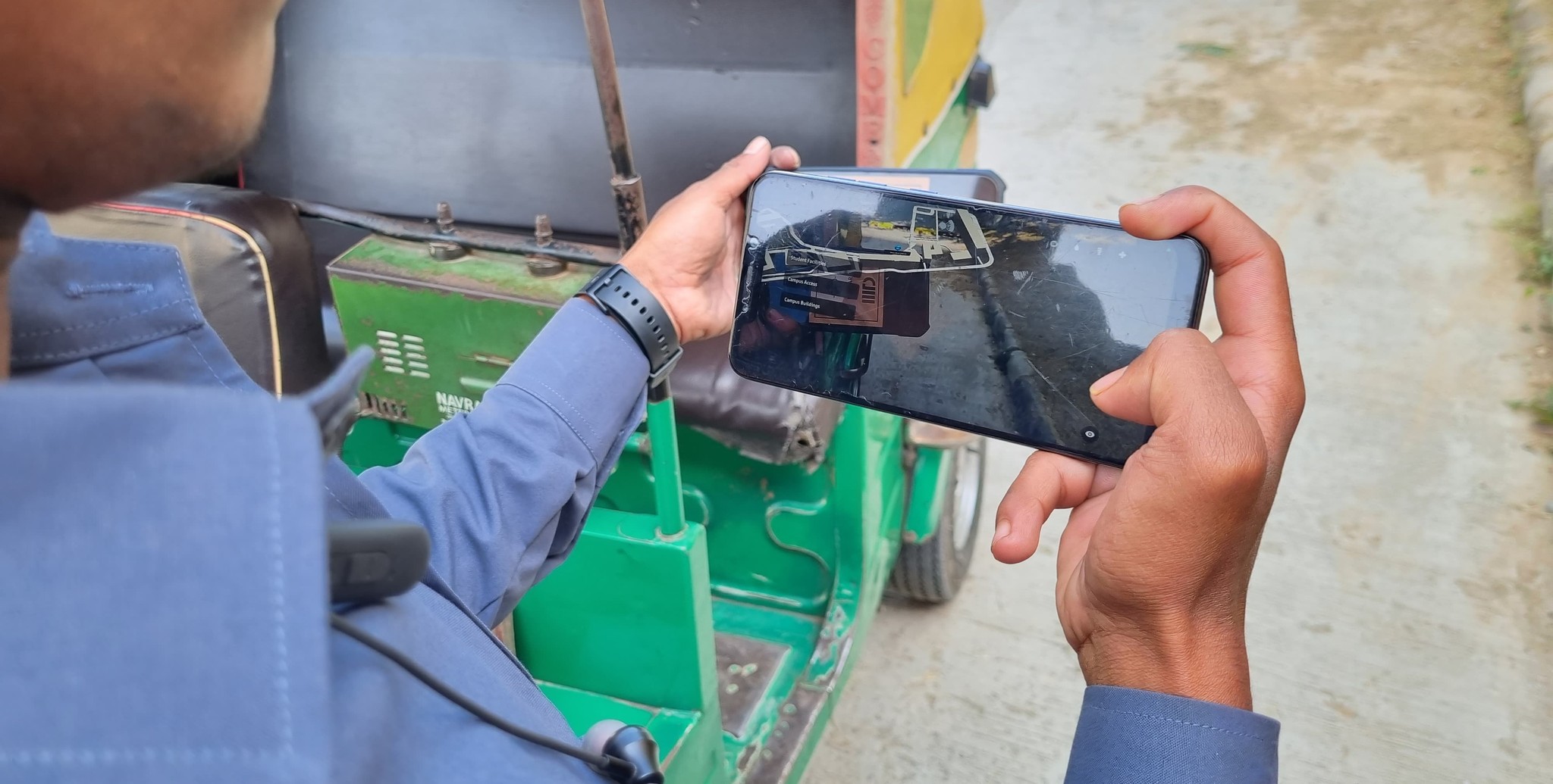
User Testing the app with an Autorickshaw Driver
In conclusion, the NavigAR project effectively showcases how Augmented Reality (AR) can enhance campus navigation at IIIT Delhi. By utilizing AR technology, the project provides an intuitive and interactive navigation experience, particularly benefiting newcomers and visitors. The use of AR markers, a campus model, and a thoughtfully designed user interface significantly improves spatial learning and wayfinding.
In conclusion, the NavigAR project effectively showcases how Augmented Reality (AR) can enhance campus navigation at IIIT Delhi. By utilizing AR technology, the project provides an intuitive and interactive navigation experience, particularly benefiting newcomers and visitors. The use of AR markers, a campus model, and a thoughtfully designed user interface significantly improves spatial learning and wayfinding.

That's the end of this one.
Wanna see another?
That's the end of this one.
Wanna see another?